
[For Part 1, of which this is a continuation, see https://villacastagnadaylesford.com.au/2018/11/12/views-of-the-colosseum-from-the-north-1-luigi-rossinis-panorama/]
A second print by Luigi Rossini is a view from the Palatine towards the Esquiline across the Colosseum, entitled Il Monte Esquilino (1827) (Figs 1, 2).
-
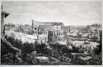
- Fig. 1. Luigi Rossini, View of the Esquiline from the Palatine (Il Monte Esquilino), 1827
-

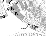
- Fig. 2. Detail of Fig. 1, labelled.
Rossini shows the arches of the substructures of the temple platform (K), which were exposed by French excavations in the Napoleonic period. These were necessary because the west part of the platform was built on the tufa bedrock, but at the east the ground dropped away and had to be built up with substructures.[1] The height of the temple platform (K) corresponds approximately to the level of the top of the lower arcade of the Colosseum. This is confirmed by modern photos (Fig. 3, from Google, taken from the Esquiline park). The fallen columns visible in the panorama are shown (B).
-

- Fig. 3. Temple platform of Temple of Venus and Rome relative to Colosseum arches, seen from the Esquiline (Google maps with addition).
To the left of the Colosseum is building F. These have changed somewhat since the eighteenth century. If we look at Nolli (Fig. 4), be can identify three components: F1a, which is a two storey building with a door; F1b, which abuts this to the right but has no door; and F1c, which is a garden. These appear in Van Wittel, where F1b is two stories and three bays wide with a roof continuous with F1a, and F1c is a garden with a garden gateway. In Rossini’s Esquiline view things are more complicated (Fig. 2). The taller middle building with its own roof is probably F1a and F1b combined, though the F1b part has only one bay. To the right is a building seemingly with a continuous roof of 5 bays with a doorway (F1d). This is probably new since Nolli and van Wittel. There is still a garden wall and gateway (F1c) between F1a and F2, but F2 seems to have acquired additions that extend into the garden.
-
- Fig. 4. Nolli map, labelled, showing building F.
Judging from the cart tracks, the post important road through the area is the one from Via Labicana around the Colosseum to the Arch of Titus, and thence through the Campo Vaccino. Mound 2 is visible, and appears to have a broad flight of steps up it.
[1] John W. Stamper, The Architecture of Roman Temples. The Republic to the Middle Ages, Cambridge: Cambridge University Press, 2005, p. 209: ‘The large platform on which the temple stood was formed by natural tufa rock on the west and built-up concrete piers and vaults on the east.’
